


bono

gnortier
User
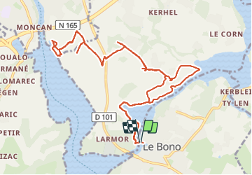

Length
14.4 km

Max alt
36 m

Uphill gradient
156 m
Km-Effort
16.5 km

Min alt
0 m

Downhill gradient
163 m
Boucle
Yes
Creation date :
2023-06-12 09:24:17.641
Updated on :
2023-06-12 14:16:30.529
4h34
Difficulty : Easy

FREE GPS app for hiking
 SityTrail
IGN / Geographical institutes
SityTrail Plus
The world is yours!
About
Trail Walking of 14.4 km to be discovered at Brittany, Morbihan, Le Bono. This trail is proposed by gnortier.
Positioning
Country:
France
Region :
Brittany
Department/Province :
Morbihan
Municipality :
Le Bono
Location:
Unknown
Start:(Dec)
Start:(UTM)
503539 ; 5276400 (30T) N.
Comments